Showing 136 items matching pine hill
-
 Greensborough Historical Society
Advertising Leaflet, 9 Pine Avenue Briar Hill, 07/11/2012
... 9 Pine Avenue Briar Hill...pine avenue briar hill...9 Pine Avenue Briar Hill. 3 bedroom home, private sale...9 Pine Avenue Briar Hill. 3 bedroom home, private sale ...9 Pine Avenue Briar Hill. 3 bedroom home, private sale, sold 7 November 2012 for $515,000Real estate advertising leaflet, 1 sheet, printed in colour both sidespine avenue briar hill -
 Ballarat Heritage Services
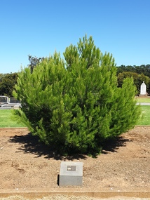
Photograph - Photograph - Colour, Clare Gervasoni, Aleppo Pine, Tower Hill Cemetery, 2019, 03/01/2019
... Aleppo Pine, Tower Hill Cemetery, 2019... of an Aleppo Pine planted in the Tower Hill Cemetery to mark ...The Tower Hill Cemetery is located near Koroit on the north side of the Princes Highway The, between Port Fairy and Warrnambool. The first burial at Tower Hill Cemetery took place in 1856. Over 150 years there has been over 8,000 burials. Around 45 percent of the burials are in unmarked graves. In 2023 this tree was no longer in existence, and a smaller tree was struggling in this site.Colour photographs of an Aleppo Pine planted in the Tower Hill Cemetery to mark the centenary of the landing at Galipolli.aleppo pine, anzac centenary, centenary, anniversary, tower hill cemetery, gallipoli -
 Ringwood and District Historical Society
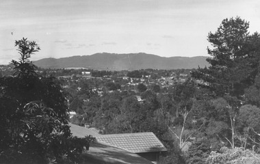
Photograph, View overlooking Ringwood from cnr Pine and Panorama, Loughnan Hill - c.1973-74
... View overlooking Ringwood from cnr Pine and Panorama... Ringwood from cnr Pine and Panorama, Loughnan Hill - c.1973-74 ...Inscriptions on backing sheets read, "1973 - from corner Pine and Panorama" and "Ringwood from Loughnan Hill, 1974". -
 Eltham District Historical Society Inc
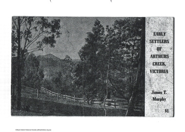
Document - Folder, James T Murphy, Early Settlers of Arthurs Creek, Victoria, 1971
... pine hill... pierre brennan pine hill richard bassett rtanks corner spicer ...Photocopy of original book: Early Settlers of Arthurs Creek, Victoria published in 1971 by James T. Murphy with an additon of a map of Shire of Eltham dated 2004.arthurs creek, harry gilham collection, archibald macfarlane, ardchattan, arthurs creek school, brennans, charles creighton, collins, cornelius stewart, davey wilson, drapers lane, duncan smith, f. sims, hazelglen, hazelglen school. alex smith, hugh macmillan, james millar brock, james sutherland, james t murphy, john bear, john macdonald, john ryder, john smith, joseph lobb, joseph murphy, maloney, michael brennan, p. green, patrick reid, pierre brennan, pine hill, richard bassett, rtanks corner, spicer, thomas murphy, william laidlay, william murphy -
 Surrey Hills Historical Society Collection
Folder of real estate advertisements, Folders of real estate advertisements (Streets beginning with P), Various
... street pine street prospect hill road proudfroot street ...A4 folders with individual pockets for each property in streets beginning with P located in Surrey Hills and Mont Albert. Folders are ordered by street name and then chronologically by property number. Each property has its own pocket. This may include multiple real estate advertisements collected from sales over time. It may also include copies of any research undertaken by Alan Holt and / or members of the SHNCHC team. These are augmented by cards in the Alan Holt index file and by his property registers of Surrey Hills and Mont Albert.park road, payne street, pembroke street, pine street, prospect hill road, proudfroot street -
 Orbost & District Historical Society
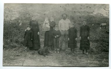
black and white photograph, 1994
... at Cunninghame. The house on the hill, now Pine Hill was named... to their new home at Cunninghame. The house on the hill, now Pine Hill ...The Roadknight family settled on Ewing's Marsh on what is now known as the Old Station In 1850. The Lakes Entrance run was occupied by the late Thomas Roadknight. In 1852 his brother William took charge. Soon after this Corringle Station was occupied by the late T. T. Stirling. William was born at Collingwood, the son of William Roadknight and Jane Stirling. The Roadknight family came from Colac on board the Enterprise to their new home at Cunninghame. The house on the hill, now Pine Hill was named Merrangbaur (home of the lyrebird). William held the Lake Tyers and Snowy River run in partnership with Thomas Telfer Stirling who took up the eastern end of the run on the west bank of the Snowy River. The run included Ewing‟s Marsh — the Ewing brothers were earlier landowners but had no formal run in this area. William served four terms on the Tambo Shire Council as a representative of the Bendoc Riding despite not being a resident of the Riding. He was then elected to the Orbost Shire as a West Riding councillor in 1896-97, 1897-98 and was Shire President in his final year 1898-99 This item is associated with Roadknight family who were early settlers in the Orbost district.A black / white photograph of a family group of mother, father and six children standing outdoor. There is a dog lying in front .roadknight-william ewing's-marsh old-station-orbost -
 Phillip Island and District Historical Society Inc.
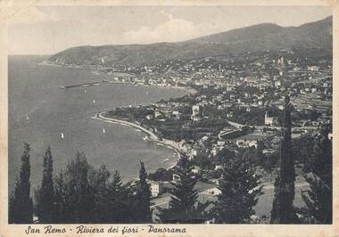
Photograph, 1950
... Aerial view of San Remo coastline with row of various Pine... coastline with row of various Pine Trees across foreground. Hills ...Personal communication from Europe to relative (Aunt Elsie) in San Remo dated 17/06/1951Aerial view of San Remo coastline with row of various Pine Trees across foreground. Hills in background. Pier at top left. Shows town area of San Remo in Italy, Europe.San Remo - Riviera Dei Fiori - Panoramaphotography, photographs, aerial view - coastal view - san remo europe, black & white photograph, comparison views san remo, aerial -
 Kiewa Valley Historical Society
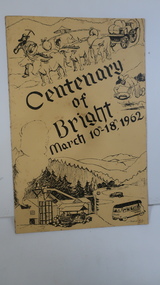
Booklet - Bright, Centenary of Bright March 10th - 18th, 1962
... sketch is at the bottom and includes hills, pines, saw mill... and includes hills, pines, saw mill and bus. Sketch at the top ...Township of Bright celebrated its centenary during the week from 10th - 18th March, 1962. This booklet outlines the program for the week.Bright is a nearby town to the the Kiewa Valley and currently the location of the current Shire (Alpine). The program gives historical information on activities in the early 1960s.Yellowy/Orange cover with brown title and sketch. One sketch is at the bottom and includes hills, pines, saw mill and bus. Sketch at the top is of a bullock team and in the middle on the right a gold miner. Inside cover has print as has both sides of the 4 pages held by 2 staples. 'C. Roper' on inside of the front cover.bright, centenary of bright -
 Ringwood and District Historical Society
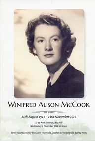
Programme, Order of Service for Funeral for Winifred Alison McCook, long standing Ringwood solicitor - 24th August 1923 - 23rd November 2015
... conducted at Le Pine Funerals, Box Hill on Wednesday 2 December... conducted at Le Pine Funerals, Box Hill on Wednesday 2 December ...Bifold Card featuring three photographs of Ms McCook, words of "Abide with me" by Henry F. Lyte, biblical readings and religious referrals. The card mentions eulogies by Margaret Fankhauser, Anne Hartnett, Julie Turner, and prayer by Rev. John Huynh. Service conducted at Le Pine Funerals, Box Hill on Wednesday 2 December, 2015. -
 Lara RSL Sub Branch
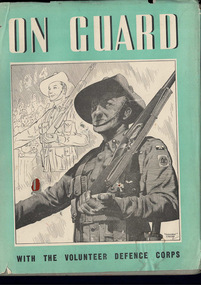
Book, On Guard with the Volunteer Defence Corps
... Krithia, Quinn's Post Lone Pine, The Nek, Hill 971, SAri... Corps Krithia, Quinn's Post Lone Pine, The Nek, Hill 971, SAri ...Krithia, Quinn's Post Lone Pine, The Nek, Hill 971, SAri Bair, Chunuk Bair, Hill 60, Fromelles, Ypres, Messines, Menin Road, Broodseinde, Polygon Wood, Paschendalle, Strazeele, Pozieres, Moquet Farm, Bullecourt, Villes Bret, Hamel, Mont St. Quintin, Peronne, Hindenburg Line, Romani, Magdhaba, Rafa, Gaza, Beersheba, Jerusalem, Jericho, Es Salt, Amman, Megiddo, Sharon, Damascus.2 x On Guard with the Volunteer Defence Corpsvolunteer defence force in wwii, europe -
 Warrnambool and District Historical Society Inc.
Map - Maps, Soldiers Settlement WW2, Circa 1950
... ( Villiers) 4277 acres .25 'Pine Hills' Estate 2nd portion ( Lowan...) 4277 acres .25 'Pine Hills' Estate 2nd portion ( Lowan) 6190 ...The soldiers' settlement scheme operated after the first and second world wars in an effort to more closely settle the land and also give opportunities to returned soldiers. Crown land and other larger estates were acquired for the purpose. Most of these maps relate to the area north of Warrnambool where many of the subdivisions were parts of larger estates.These maps pertaining to the Soldiers' Settlement program, relate to an interesting part of Australian and local history. As such they have historic and social interest and significance.A collection of 25 paper maps which relate to to the soldiers settlement post World War 2. Some have details of the people allocated the land and some smaller maps have the printed details of the applicants requirements.Text is black on white paper which in some cases is quite aged. The maps are as follows: .1 Narrapumelap Estate ( Ripon & Hampden) .2 Narrapumelap Estate Part 2 (Villers & Ripon) .3 Narrapumelap Estate Part 3 ( Villiers & Ripon) .4 Burrumbeet Estate ( Ripon) .5 ' Berrambool' Estate 9 Hampden & Villiers) .6 ' Hopkins Hill' Estate Villiers 4011 acres .7 Caramut North No 2 Estate ( Villiers ) .8 ' Morpor' Estate ( Villiers) 4172 acres .9 ' Morgiana' Estate ( Normandy) 3453 acres .10 ' Chatsworth House' ( Villiers) 9341 Acres .11 ' East Elwood' Estate Villiers 2407 acres .12 Grey's Estate ( Mornington) 1151acres .13 ' Rowes Estate' ( Buln Buln Gippsland 733 acres .14 'Tarrone' Estate No 2 Part map .15 'Chaldon Meade' Estate (Bourke) Bulla 517 acres .16 ' Terranallum South' Estate Hampden 3757 acres .17 ' Brung Brungle' Estate Dundas 695 .18 ' Armidale ' Estate ( Dundas)2108 acres .19 ' Moyne Falls' Estate ( Villiers) 627 acres .20' Yulong' Estate 9 Lowan 6321 acres .21 Murray Valley Irrigation District 9 Moira)113 acres .22 Murray Valley Irrigation District 103 acres .23 ' Mount Fyans' Estate ( Hampden) .24 ' Barwidgee ' Estate ( Villiers) 4277 acres .25 'Pine Hills' Estate 2nd portion ( Lowan) 6190 acres narrapumelap, berrambool, hopkins hill, caramut north, morpor, chatsworth house, east elwood, terrinallum, moyne falls, tarrone, caramut soldiers settlers, burrumbeet, morgiana, grey's estate mornington, chaldon meade, brung brungle -
 Eltham District Historical Society Inc
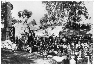
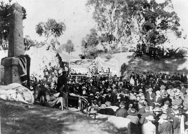
Negative - Photograph, Unveiling of War Memorial Obelisk, corner of Main Road and Bridge Street, Eltham, 3 Aug. 1919
... of "Pioneers & Painters." "Beneath a lonely pine tree on the hill... of "Pioneers & Painters." "Beneath a lonely pine tree on the hill ...The unveiling of the Eltham Obelisk War Memorial was performed by the Rev. Padre Charles Tregear, assisted by Church of England vicar, Mr Safsford on August 3, 1919. Reproduced page 99 of "Pioneers & Painters." "Beneath a lonely pine tree on the hill crest out from Eltham, where the Greensborough Road junctions with the main Melbourne Road, Eltham has erected an everlasting tribute to the memory of the fallen heroes of the district. It is an obelisk of Harcourt granite in the rough, bearing an appropriate inscription and 27 names—an unpretentious monument by the wayside, which will stand for all time silently expressing the appreciation of the living for the sacrifice of the dead. The obelisk stands 14 feet high. ... Representatives of every house in the town, and many people from the surrounding district, gathered around the obelisk for the opening ceremony. The spring-like sunshine of the afternoon attracted everybody out of doors. There must have been 700 people present when the Lieutenant-Governor, Sir William Irvine, removed the draping of flags and revealed the names on the obelisk, the base of which was surrounded by wreaths and branches of wattle bloom, placed there by parents whose sorrow at the loss of sons was blunted, for the day at least, by feelings of pride. .." Age, Monday 4 August 1919, page 8 This was the memorial's orginal location. It has been relocated numerous times.This photo forms part of a collection of photographs gathered by the Shire of Eltham for their centenary project book,"Pioneers and Painters: 100 years of the Shire of Eltham" by Alan Marshall (1971). The collection of over 500 images is held in partnership between Eltham District Historical Society and Yarra Plenty Regional Library (Eltham Library) and is now formally known as the 'The Shire of Eltham Pioneers Photograph Collection.' It is significant in being the first community sourced collection representing the places and people of the Shire's first one hundred years.Digital image 4 x 5 inch B&W Negsepp, shire of eltham pioneers photograph collection, eltham, main road, bridge street, eltham war memorial, obelisk, obelisk corner -
 Eltham District Historical Society Inc
Negative - Photograph, Unveiling of War Memorial Obelisk, corner of Main Road and Bridge Street, Eltham, 3 Aug. 1919
... of "Pioneers & Painters." "Beneath a lonely pine tree on the hill...." "Beneath a lonely pine tree on the hill crest out from Eltham ...The unveiling of the Eltham Obelisk War Memorial was performed by the Rev. Padre Charles Tregear, assisted by Church of England vicar, Mr Safsford on August 3, 1919. Reproduced page 99 of "Pioneers & Painters." "Beneath a lonely pine tree on the hill crest out from Eltham, where the Greensborough Road junctions with the main Melbourne Road, Eltham has erected an everlasting tribute to the memory of the fallen heroes of the district. It is an obelisk of Harcourt granite in the rough, bearing an appropriate inscription and 27 names—an unpretentious monument by the wayside, which will stand for all time silently expressing the appreciation of the living for the sacrifice of the dead. The obelisk stands 14 feet high. ... Representatives of every house in the town, and many people from the surrounding district, gathered around the obelisk for the opening ceremony. The spring-like sunshine of the afternoon attracted everybody out of doors. There must have been 700 people present when the Lieutenant-Governor, Sir William Irvine, removed the draping of flags and revealed the names on the obelisk, the base of which was surrounded by wreaths and branches of wattle bloom, placed there by parents whose sorrow at the loss of sons was blunted, for the day at least, by feelings of pride. .." Age, Monday 4 August 1919, page 8 This was the memorial's orginal location. It has been relocated numerous times.This photo forms part of a collection of photographs gathered by the Shire of Eltham for their centenary project book,"Pioneers and Painters: 100 years of the Shire of Eltham" by Alan Marshall (1971). The collection of over 500 images is held in partnership between Eltham District Historical Society and Yarra Plenty Regional Library (Eltham Library) and is now formally known as the 'The Shire of Eltham Pioneers Photograph Collection.' It is significant in being the first community sourced collection representing the places and people of the Shire's first one hundred years.Digital image 4 x 5 inch B&W Neg Print 9 x 12.5cmsepp, shire of eltham pioneers photograph collection, eltham, main road, eltham war memorial, bridge street, obelisk, obelisk corner -
 Greensborough Historical Society
Photograph - Digital Image, Frank Hills and cockatoo, 1942c
Black and white photograph of Frank Hills with a cockatoo with Methodist church and Bunya pine in background c 1942Digital copy of black and white photograph.frank hills, greensborough methodist church -
 Federation University Historical Collection
Photograph, Kodak Australia, Frank Wright's Parents at Laura Villa, Smeaton, 1922
... hand side of the photograph is a hill with a large pine tree... of the photograph is a hill with a large pine tree. The people are Sarah ...Frank Wright was a renown resident of Smeaton, where he was born. He lived at Laura Villa, and attended Smeaton State School. His father William was a gold miner and his mother's name was Sarah. Their family won many singing and instrumental awards. Frank was tutored by Percy Code and became the Australian Open Cornet Champion by the age of eighteen. A year later, Frank conducted the City of Ballarat Band, and later the Ballarat Soldiers’ Memorial Band. He formed the Frank Wright Frisco Band and Frank Wright and his Coliseum Orchestra. These bands won many South Street awards, and Frank as conductor won many awards in the Australian Band Championship contest. In 1933 Frank Wright sailed to England to conduct the famous St Hilda’s Band and was later appointed Musical Director of the London County Council, where he organized many amazing concerts in parks, in and around the London district. He was made Professor of Brass and Military Band Scoring and conducted at the Guildhall of Music and Drama. Frank was often invited to adjudicate Brass Band Championships around Europe, in Australia, including South Street and in New Zealand. The Frank Wright Medal at the Royal South Street competition is awarded to an individual recognized as making an outstanding contribution to brass music in Australia.Sepia photograph of a man and a woman standing in front of a picket fence which surrounds a timber cottage with a corrugated iron roof, including a striped front verandah roof. On the left hand side of the photograph is a hill with a large pine tree. The people are Sarah and William Wright and the cottage is "Laura Villa" at Smeaton.Printed on back - Post Card, Kodak Australiafrank wright, sarah wright, william wright, laura villa, smeaton, picket fence -
 Federation University Historical Collection
Book, Final recommendations Ballarat Study Area Land Conservation Council, Victoria, 1982
Yellow soft covered report of 95 pages . The contents of the report include: Parks, reference areas, wildlife reserves, water production, harwood production, softwood production, flora Reserves and Flora and Fauna reserves, bushland reserves, historic area and reserves, rivers and streams, Roadside conservation and Highway parks, Education areas and School Plantations, Lake Reserves, geological reserves, recreation, scenic reserves, agriculture, mineral and stone production, utilities and survey, township land, Uncommitted Land, military training, other reserves and public land. Maps include: The Study area 1: 250 000 Supplementary Mapsland conservation authority, ballarat, endowment plantations, pine plantations, langi ghiran state park, mount buangor state park, enfield state park, ballarat-creswick regional park, rossbridge, black lake, flax mill swamp, dereel lagoon, lake bolac, lake wongan, langi ghiran reservoir, gong gong reservoir, pincotts reservoir, beales reservoir, wilsons reservoir, moorabool reservoir, korweinguboora, korweinguborra reservoir, learmonth bores, sago hill, illabarook reservoir, ballarat water commission, dunneworthy, mount cole, mont lonarch, ben major, waterloo, trawalla, linton, ross creek, canadian, shepherds flat, lal lal, mount doran, raglan, chute, carngham, buninyong, watsons hill, enfield, cape clear, illabrook, rokewood junction, mount warrenheip, nerrina, jubilee, golden stream, australasian deep lead mine, happy valley school, piggoreet, berringa, bulldog, ballarat common, wildlife, water, timber, flora, rivers, geology, agriculture, warrenheip -
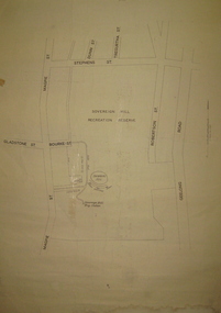 Federation University Historical Collection
Plan, Sovereign Hill Recreation Reserve and Surrounds
This map was probably produced around the time that the Sovereign Hill Museums Association was established. A simple plan with black marking on paper. It shows the Sovereign Hill Recreation Rerserve, including the swimming pool located near the Sovereign Hill Trig Point, showers, toilets, kiosk, bandstand and pine trees. The plan also depicts the Ballarat East streets surrounding Sovereign hill, including Geelong Road, Magpie Street, Stephens Street, Tregurtha Street, Dunn Street, Bourke Street, Gladstone Street and Robertson Street. The scale is 2 chains to 1 inch.sovereign hill, swimming pool -
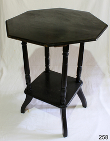 Flagstaff Hill Maritime Museum and Village
Furniture - Table
... Flagstaff Hill Maritime Museum and Village 89 Merri Street ...Centre table, hexagonal in shape, coloured cedar, lower shelf supported by four turned columns and finished on four splayed legs. Kauri Pine.flagstaff hill, warrnambool, shipwrecked-coast, flagstaff-hill, flagstaff-hill-maritime-museum, maritime-museum, shipwreck-coast, flagstaff-hill-maritime-village -
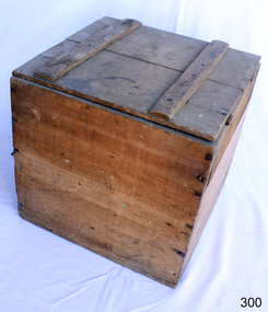 Flagstaff Hill Maritime Museum and Village
Container - Box
From the earliest days, humans have furnished their dwellings with the items they needed to survive and over the centuries the wooden chest, storage boxes and trunks have become the most common piece of furniture found in the home. Over time the simple storage chest has evolved into different styles and been modified for different uses: wooden boxes, storage chests, tool chests, treasure chests, blanket boxes and steamer trunks. Wooden chests and trunks have became the most useful, and most versatile piece in furniture’s history. https://www.vineyarddetails.com/blogs/february-2019/history-of-box-makingThe use of the wooden box for storage.Wooden square handmade box with hinged lid. Made from rough pine boards.None.flagstaff hill, warrnambool, shipwrecked-coast, flagstaff-hill, flagstaff-hill-maritime-museum, maritime-museum, shipwreck-coast, flagstaff-hill-maritime-village, wooden box, furniture, storage -
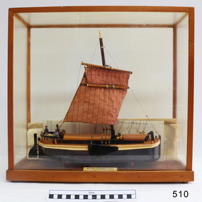 Flagstaff Hill Maritime Museum and Village
Craft - Ship model, 28-01-1985
This unnamed ship model was built by a Warrnambool resident. The Humber Keel design is typical sailing craft used for transport if inshore and inland cargo, from Humber and Hill, around Yorkshire, U.K. in late 19th and early 20th century. Ship model, single mast, double spar, humber keel. Two tone brown and cream paint, light brown sail. Figures of a man, woman and dog on deck. A type of vessel used on the Yorkshire waterways. Perspex case with wooden frame. Folded plans are inside case. Nameplate Plaque inside case describes ship."RIVER HUMBER KEEL/YORKSHIRE/LENGTH 61', BEAM 15'6", DR G CAP 100 TONS/CREW MAN & WIFE, SCALE 1:40/HUON PINE etc. E.H. GRANGER 28.1.1985" on plaque inside caseflagstaff hill, warrnambool, shipwrecked-coast, flagstaff-hill, flagstaff-hill-maritime-museum, maritime-museum, shipwreck-coast, flagstaff-hill-maritime-village, humber keel, sailing cargo -
 Flagstaff Hill Maritime Museum and Village
Tool - Caulking Tool, Ward & Payne Ltd, Late 19th century
Caulking is the traditional technique used on wooden vessels built with butted or clinker-built planks to fill the gaps between these planks while still allowing the wood to flex and move. This involved driving the irons, hammered in with the mallet, deep into the seams to open them up. After this, spun yarn, oakum (hemp) or cotton was driven deep into the gaps. The hemp or cotton was soaked in creosote or pine tar to make the joins watertight. Caulking also played a structural role in tightening up the hull or deck by reducing the longitudinal movement of the neighbouring planks. The subject item was made by Ward & Payne of the Limbrick Works at Hillsborough, Sheffield England manufacturers of hand-forged tools. Their trademark registered in 1850 was a Letter "W" & "P" stamped into the steel. The firm was established by David Ward (1767-1822) in 1803 the company became David Ward & Sons, in 1837 after Ward's son Edward joined the firm. In 1845 Henry Payne the founder's son-in-law became a partner but died in 1850 after which the company reverted to the Ward family. The business then concentrated on making carving tools, chisels and gouges. In 1882 David Ward's grandson David Ward Jr. (1835-1889) purchased land and built a factory at Sheffield North known as the "Limerick Wheel". For a time Wards operated from both 106-114 West Street Sheffield and at Limbrick Road, Hillsborough on the river Loxley. By 1911 they had expanded into making spades, forks, sheep shears and many other types of edged tools including drills and wood planes. In 1967 Wilkinson Sword purchased all the company's share capital and continued to sell Ward & Payne tools until 1970 when a fire burned the factory down and housing development was built on the site. The subject item is significant as it gives a snapshot of the technological development of sailing ships and their operation before steam-powered vessels took over around the world. Tools such as the subject item demonstrate the traditional craftsmanship and skill of the shipwright and the aesthetic quality of the timber ships designs of the time. Caulking tool with square end"WARD Sheffield"flagstaff hill, warrnambool, flagstaff hill maritime museum, shipwreck coast, flagstaff hill maritime village, james s steele, caulking iron, caulking tool, shipwright tools, ward & payne sheffield, forged tools -
 Flagstaff Hill Maritime Museum and Village
Furniture - Sideboard, Circa 1880
This sideboard was from the home of Henry and Mary Jane Giles, who lived in Mailor's Flat, Wangoom, and Purnim West, Victoria, and is part of the many 19th century items of furniture, linen, and crockery donated to Flagstaff Hill Maritime Village by, Vera and Aurelin Giles. The items are associated with Warrnambool and the Giles Family history. Items donated by the family have come to be known as the “Giles Collection”. Many items in the Lighthouse Keeper’s Cottage were donated by Vera and Aurelin Giles and mostly came from the home of Vera’s parents-in-law, Henry Giles, and his wife Mary Jane (nee Freckleton) who married in 1880 and whose photos are on display in the parlour. Henry was born at Tower Hill in 1858, and was a labourer on the construction of the Warrnambool Breakwater before leaving in 1895 for around seven years to build bridges in NSW. Mary Jane was born in 1860 at Cooramook and she attended Mailor’s Flat State School and where she eventually was to become a student-teacher. After which she became a governess at “Injemiara” where her grandfather, Francis Freckleton, had once owned land. Henry and Mary’s family consisted of six, some of the children were born at Mailor’s Flat, and later some children at Wangoom. They lived with their parents at Wangoom and Purnim west, and this is where Henry died in 1933 and Mary Jane in 1940.The Giles family collection is of social significance at a local level, because it not only illustrates the level of material support the Warrnambool community gave to Flagstaff Hill during it’s establishment. But the Giles collection also gives us today a snapshot into what domestic life was like in early colonial times prior to Federation.Kauri Pine Mirror Backed Sideboard, two drawers and two doors to the base, the doors being carved in the traditional manner with a leaf design, brass swing handles are fitted to each of the drawers. The back has two shelves each supported on two turned columns, three mirrors are fitted into carved panels matching design as doors.The pediment is also carved in the same manner finishing with scrolled edges. Circa 1880. This item is part of the Giles Collection.Marked "Villa Rica" "Ambassadors" "Claro" "50" In pencilflagstaff hill, warrnambool, shipwrecked coast, flagstaff hill maritime museum, shipwreck coast, flagstaff hill maritime village, sideboard, furniture, dresser, giles collection, henry giles, vera giles, tower hill, cooramook, mailor’s flat, wangoom, 19th century furniture, purnim west, 1880s furniture -
 Flagstaff Hill Maritime Museum and Village
Desk
Desk wooden Baltic pine with slight slope on top, one centre drawer with keylock, plain legs. 1379mmL x 73.5mmW x 82mmH front & 87mmH back Circa 1880flagstaff hill, warrnambool, shipwrecked-coast, flagstaff-hill, flagstaff-hill-maritime-museum, maritime-museum, shipwreck-coast, flagstaff-hill-maritime-village -
 Flagstaff Hill Maritime Museum and Village
Bowl
According to Lloyd's Shipping Register 1837-1839, the CHILDREN was built in 1825 at Liverpool and operated by owners Gordon & Co, of London. London registered number 123/1837. James Henty then bought her in 1837 as a three-masted barque of 254 tons, with a hull of “part pitch pine, felt sheathed” and “coppered 1837”. Launceston registered number 6/1837. In 1838 the CHILDREN, under her master Captain H. Browne, completed a successful round trip from Launceston to London (carrying wool and whale oil loaded in Portland), returning in late November of that year (carrying a general cargo including the house bricks). On the 11th January 1839, the CHILDREN sailed from Launceston for Adelaide, with 24 passengers, 14 crew, and an awkward mixed cargo, including 1500 sheep, 8 bullocks, 7 horses, and farming implements, and six whaleboats with associated whaling gear. One account states that when the CHILDREN “put out from port she was light and badly ballasted”. The vessel immediately encountered four days of hurricane force storms, eventually clearing on the early morning of the 14th to “west force 10”, but too late to take accurate measurements of the sun or stars to establish their position relative to the coast. The CHILDREN collided with a limestone stack at the entrance of Childers Cove, and the seas smashed her into pieces within half an hour. All the cargo and 16 lives were lost (including 8 children). The Henty’s contributed £150 towards a fund for the 22 survivors at a memorial service held in Launceston later that year. It was a major financial setback for the Henty’s, but one from which they recovered. In a submission to the Governor of New South Wales dated 24 March 1840, the Henty’s summarised their work over the previous six years of settlement: “Six stations have been occupied, one at Portland Bay…three at the open country about 60 miles inland called ‘Merino Downs’…They have erected two houses at Portland Bay and two others at Merino Downs”. The shipwreck of the CHILDREN is of State significance ― Victorian Heritage Register S116Part of terracotta bowl from the wreck of the Children, 2 segments have been glued together.flagstaff hill, warrnambool, shipwrecked-coast, flagstaff-hill, flagstaff-hill-maritime-museum, maritime-museum, shipwreck-coast, flagstaff-hill-maritime-village, children -
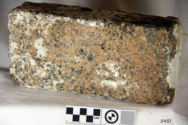 Flagstaff Hill Maritime Museum and Village
Brick
According to Lloyds Shipping Register 1837-1839, the CHILDREN was built in 1825 at Liverpool and operated by owners Gordon & Co, of London. London registered number 123/1837. James Henty then bought her in 1837 as a three-masted barque of 254 tons, with a hull of “part pitch pine, felt sheathed” and “coppered 1837”. Launceston registered number 6/1837. In 1838 the CHILDREN, under her master Captain H. Browne, completed a successful round trip from Launceston to London (carrying wool and whale oil loaded in Portland), returning in late November of that year (carrying a general cargo including the house bricks). On the 11th January 1839, the CHILDREN sailed from Launceston for Adelaide, with 24 passengers, 14 crew, and an awkward mixed cargo, including 1500 sheep, 8 bullocks, 7 horses, and farming implements, and six whaleboats with associated whaling gear. One account states that when the CHILDREN “put out from port she was light and badly ballasted”. The vessel immediately encountered four days of hurricane force storms, eventually clearing on the early morning of the 14th to “west force 10”, but too late to take accurate measurements of the sun or stars to establish their position relative to the coast. The CHILDREN collided with a limestone stack at the entrance of Childers Cove, and the seas smashed her into pieces within half an hour. All the cargo and 16 lives were lost (including 8 children). The Hentys contributed £150 towards a fund for the 22 survivors at a memorial service held in Launceston later that year. It was a major financial setback for the Henty’s, but one from which they recovered. In a submission to the Governor of New South Wales dated 24 March 1840, the Henty’s summarised their work over the previous six years of settlement: “Six stations have been occupied, one at Portland Bay…three at the open country about 60 miles inland called ‘Merino Downs’…They have erected two houses at Portland Bay and two others at Merino Downs”. The shipwreck of the CHILDREN is of State significance ― Victorian Heritage Register S116Fired brick from the wreck of the Children, flagstaff hill, warrnambool, shipwrecked-coast, flagstaff-hill, flagstaff-hill-maritime-museum, maritime-museum, shipwreck-coast, flagstaff-hill-maritime-village, children -
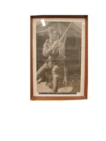 Red Cliffs Military Museum
Framed Photograph, Sargent W.T. West 24th Battlion A.I.F. 1914-1918, (estimated); WW1
A plaque beside the photograph tells us it was taken on Hill 60, Galipolli. It also states that Sargent West returned with a seed from pines at Lone Pine and from that seed the Pine at the Cenotaph in Barclay Square Red Cliffs grew.A framed balck and white photograph of Sargent W.T. West, cleaning his rifle infront of his tent, the photo clearly shows his rank insignis and uniform and hat details, as well as his Lee Enfield rifle.of, australia, ww1, commonwealth, gazette, london, walter, thomas, west, mm, mc, collection, 24th, battalion, aif -
 Eltham District Historical Society Inc
Photograph, Edendale Farm, Eltham Heritage Tour, 24 May 1992, 24/05/1992
ELTHAM HERITAGE TOUR The Society excursion on 24th May 1992 was arranged by David Bick, leader of the team carrying out the Shire's heritage study. David selected a number of sites or buildings identified in the study, some of them lesser known components of the Shire's heritage. The tour commenced at the Eltham Shire Office at 10.00 am. Travel was by private car and mini-bus with stops at about twelve locations for commentary by David.It included a short walk in Hurstbridge and lunch at Kinglake. Highlights of the tour included: - 10 am Leave from Shire Offices - 3 Important Trees - A Physical Link to Eltham's First Settlers - Toorak Mansion Gates - A Surviving Farm House - An Intact Circa 1900 Main Street - First Settlers - Gold Miners, and Timber-getters - An Early Hotel - A Pioneering Homestead - Changing Eltham Shire - 20th Century - 4 pm Afternoon Tea and Finish Tour Extract from ELTHAM CULTURAL HERITAGE TOUR (Newsletter No. 85, July 1992, by Bettina Woodburn) "The land was unprofitable for intensive farming, but there was always water in the Diamond Creek. The railway, a technological advance, followed the valley, and was provided to transport produce. At North Eltham we were privileged to tour a surviving farmhouse of the 1860-70 era at the Shire’s Edendale Farm, with the as yet unfinished Sculpture for a front fence - bulbous tree-trunks decorated with salt pots, with cross members from the old trestle bridge. As was usual these six veranda posted houses faced South (or East, away from the sun!) with the scullery, kitchen and pantry "out the back". The veranda, which must have been very narrow, no longer exists. It probably wrapped around three sides. The drive took us past the Dutch Windmill, only twenty years old and in the Shire of Diamond Valley, then the Diamond Creek Cemetery with impressive gateway, to a detour to see another old farmhouse, isolated on a hill off Murray Road Wattle Glen. Here was a particularly thick patch of exotic planting of pines and cypresses. Subsistence farming no longer pays. Following the rail-line we noticed on the left near Silvan Road an Edwardian cottage and on the right near Yates Road the old school residence for this Upper Diamond Creek area."Record of the Society's history and activities and highlighting various aspects of the Heritage Study undertaken by David Bick used to create the future heritage overlay for the Shire of Eltham and later Nillumbik Shire.Roll of 35mm colour negative film, 4 stripsKodak Gold 100 5095eltham, shire of eltham historical society, activities, heritage tour -
 Eltham District Historical Society Inc
Photograph, Kangaroo Ground War Memorial, Eltham Heritage Tour, 24 May 1992, 24/05/1992
ELTHAM HERITAGE TOUR The Society excursion on 24th May 1992 was arranged by David Bick, leader of the team carrying out the Shire's heritage study. David selected a number of sites or buildings identified in the study, some of them lesser known components of the Shire's heritage. The tour commenced at the Eltham Shire Office at 10.00 am. Travel was by private car and mini-bus with stops at about twelve locations for commentary by David.It included a short walk in Hurstbridge and lunch at Kinglake. Highlights of the tour included: - 10 am Leave from Shire Offices - 3 Important Trees - A Physical Link to Eltham's First Settlers - Toorak Mansion Gates - A Surviving Farm House - An Intact Circa 1900 Main Street - First Settlers - Gold Miners, and Timber-getters - An Early Hotel - A Pioneering Homestead - Changing Eltham Shire - 20th Century - 4 pm Afternoon Tea and Finish Tour Extract from ELTHAM CULTURAL HERITAGE TOUR (Newsletter No. 85, July 1992, by Bettina Woodburn) "Now we drove through stands of pines to the Kangaroo Ground Lookout Tower, a most unusual War Memorial, World War I. The tower and a shed/residence (it had a chimney) were built from local sandstone. Below to the south and east of Melbourne spread 'suburbia'. Close by the landscape seemed so contrived - English fields and hedgerows! Although only about twenty inches deep, the soil of this ancient volcano, its crater lost under subsequent weathering, was rich, deserving the name of "Garden Hill". Now native trees are taking over again. In Kangaroo Ground itself stand the inevitable Store, School and Church - and two Norfolk pines and a monkey puzzle tree."Record of the Society's history and activities and highlighting various aspects of the Heritage Study undertaken by David Bick used to create the future heritage overlay for the Shire of Eltham and later Nillumbik Shire.Roll of 35mm colour negative film, 4 stripsKodak Gold 100 5095shire of eltham historical society, activities, heritage tour, kangaroo ground, kangaroo ground tower, war memorials, kangaroo ground memorial -
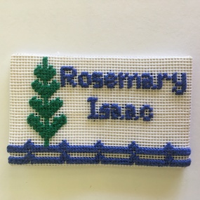 Warrnambool and District Historical Society Inc.
Badge, Rita Williams (designer), South Western Branch Embroiders Guild, late 20th century
This name badge belonged to Rosemary Isaac, a member of the South Western Branch of the Embroiderers Guild of Victoria. The badge, designed by long-time member Rita Williams, shows a Norfolk Island pine tree and a fence line. The South Western Branch of the Embroiderers Guild of Victoria was formed in Warrnambool in November 1974. Its first major project was the making of a patchwork quilt for the Lighthouse Keepers cottage at Flagstaff Hill. This was presented to the Warrnambool and District Historical Society at a meeting of the Embroiderers Guild attended by Historical Society members and representatives of Flagstaff Hill Maritime Village in October 1976. This badge is kept as a memento of the work of the local Embroiderers Guild, a prominent community organization in Warrnambool and district.This is a rectangular-shaped cloth badge with blue and green stitching on a white cloth surface. ‘Rosemary Isaac’south western group of the embroiderers guild of victoria -
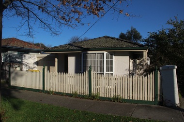 Surrey Hills Historical Society Collection
Photograph - 9 Pine Street, Surrey Hills, On The Street Where You Live Project
... Surrey Hills melbourne 9 Pine Street, Surrey Hills Photograph ...Photos documenting this address as part of a photographic series undertaken by volunteer photographers during 2013 and 2014 for The Street Where You Live Project. This was organised through the Surrey Hills Neighbourhood Centre and covered the postcode 3127 in the cities of Boroondara and Whitehorse.These photos provide a snapshot of real estate in the suburbs of Mont Albert and Surrey Hills during a period of rapid change with many properties on large blocks demolished to create higher density residential development or renewal of single dwellings. At particular risk were properties not covered by heritage overlays, especially interwar housing and post 1950's housing.